
CORPUS CHRISTI, Texas — The National Hurricane Center has marked the Atlantic Basin's first area of interest of 2026, a yellow-highlighted zone in the Bay of Campeche — but there is no threat of 'tropical trouble' for the Coastal Bend.
Why is there a yellow mark?
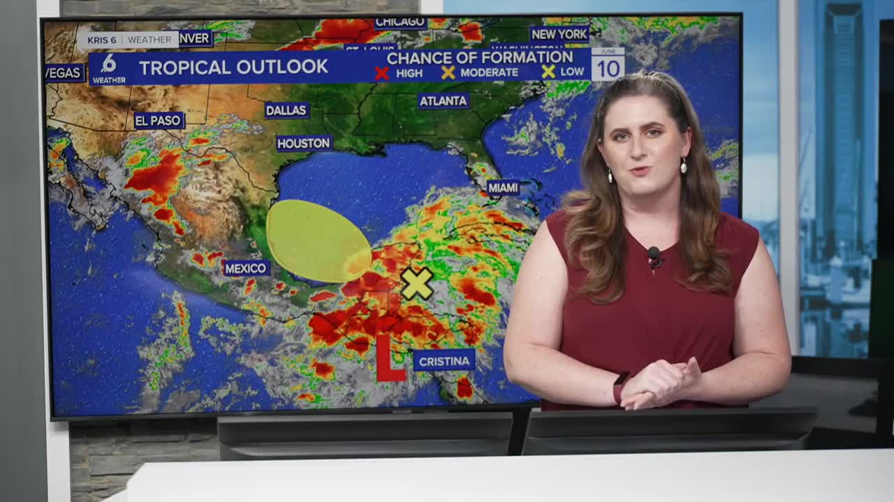
As of Wednesday night, what remains of Christina, a storm that formed in the Eastern Pacific, is the reason for the designation. Christina did not originate in the Atlantic Basin. It formed west of Central America, in the Eastern Pacific Ocean (known as the Eastern Pacific Basin) which has an entirely separate hurricane season begins on May 15. The Eastern Pacific is already on its 3rd named storm of the season: Christina.
As Christina crosses Central America, the region's mountainous terrain will continue to tear the storm apart. The water and energy from the storm have to go somewhere! The tropical moisture and will to continue drifting into the Bay of Campeche, and the NHC is closely monitoring. But there's not much chance for tropical development.
The National Hurricane Center has marked the area because there remains a very slim — nearly zero — chance of development, and by definition, any area with even minimal potential for organization must be flagged. Still, there is no direct threat to the coastal bend.
What's happening in the atmosphere
The subtropical jetstream, which has been delivering showers and storms into the region over the past several weeks, remains in place. A wave or 'wrinkle' of low pressure with also be near the Coastal Bend. This pattern, combined with the tropical moisture left over from Christina, is expected to bring plentiful rainfall back to much of South Texas this weekend and into next week.
Once a tropical storm, Christina has weakened to a tropical depression. The storm will decay further into a tropical disturbance — a loosely organized cluster of showers and thunderstorms — as it moves into the Bay of Campeche.
More obstacles than favorable conditions
Several factors are working against any tropical development in the Bay of Campeche:
- High pressure over the southeastern U.S. is nudging closer and occupying much of the Gulf.
- Moderate wind shear is expected to increase, driven by a wrinkle of low pressure that will also bring rain chances to South Texas.
- The mountainous terrain of Central America continues to disrupt the storm's circulation
- This storm will move inland over Mexico quickly, giving little time for redevelopment
Saharan dust can also hinder tropical development, but is not very present nor is it a significant obstacle in the Gulf at this time.
Rain forecast for the coastal bend
The focus now shifts to how the tropical moisture will affect the local forecast. Rain chances, which had been limited to a few isolated showers this weekend, seem more likely. Widely scattered showers and storms will become numerous by Monday and Tuesday. Monday into Tuesday is expected to be the wettest stretch of the next several days.
Because the moisture is tropical in origin, rainfall could be heavy at times. The current forecast calls for 2 to 3 inches of rain from now through June 17, with some areas potentially receiving up to 4 inches of rainfall, depending on how the pattern evolves. Rain is expected to begin Saturday and continue through the middle of next week.
Seeing as the Coastal Bend has struggled with flooding in recent rain events, flooding is possible, and I will be monitoring that risk closely.
On the positive side, the southern portion of the Nueces River watershed — currently experiencing the worst drought conditions within the watershed — stands to benefit significantly from this rainfall. The totals are likely to chip away at our drought and usher rainfall runoff into local reservoirs, though the forecast remains subject to change.
Rough surf and coastal flooding will continue to be a challenge, so please continue to swim safely, with a buddy.
The bottom line
I am not expecting tropical development, and there is no tropical threat headed to the coastal bend. The primary concern is the potential for heavy downpours and localized flooding. Rainfall returns this weekend and I expect Monday to be the wettest day of the next 7 days, if not Tuesday. That is when heavy downpours are most likely, and flooding is possible. I will be watching that risk very carefully.
Have you made your hurricane plan yet? Click here to create your own printable Hurricane Command Center guide!
This story was reported on-air by a journalist and has been converted to this platform with the assistance of AI. Our editorial team verifies all reporting on all platforms for fairness and accuracy.